
Growing GLOF Risk in the Himalayas
Retreating Himalayan glaciers are creating and enlarging glacial lakes. Sudden failure of weak moraine dams can release enormous volumes of water and generate destructive downstream floods.
Growing GLOF Risk in the Himalayas
- Syllabus Mapping: GS Paper I — Physical Geography; GS Paper III — Disaster Management, Climate Change and Environmental Security.
- Source & Date: The Indian Express, 30 October 2026.
Why in News?
A Glacial Lake Outburst Flood (GLOF) occurred at Shintaphu Lake in Bhutan, prompting downstream flood alerts along the Sankosh river system, including parts of Assam and West Bengal.
The event highlights a wider Himalayan challenge: retreating glaciers are creating and enlarging glacial lakes in high-altitude terrain, while settlements and infrastructure downstream remain exposed to sudden flood waves.
What is a GLOF?
A glacial lake is a water body formed in front of, beside, beneath or sometimes on a glacier.
Many such lakes are held back by moraines, which are loose accumulations of rock, gravel, sand and other debris deposited by glaciers.
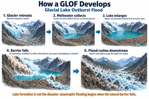
Unlike engineered dams, moraine barriers may be weak and unstable. If they suddenly fail, enormous quantities of stored water can rush downstream within a short period. This sudden release is called a Glacial Lake Outburst Flood.
How Does a GLOF Occur?
A lake does not necessarily burst simply because it becomes large.
Failure may be triggered by an avalanche, landslide, icefall, intense rainfall, earthquake, erosion of the moraine barrier or progressive weakening of the dam.
When material suddenly falls into the lake, it can generate a displacement wave that overtops the moraine. The escaping water then rapidly erodes the barrier, converting a small breach into a major flood.
Why the Himalayas Are Vulnerable
The Hindu Kush Himalaya contains extensive glacier systems that are responding to rising temperatures.
As glaciers lose mass and retreat, depressions left behind can fill with meltwater. Existing lakes may also expand as the glacier front moves backwards.
The Himalayan terrain magnifies the danger. Steep slopes increase the probability of avalanches and landslides, while narrow valleys can concentrate floodwater and debris into powerful downstream flows.
CWC-NRSC monitoring has identified thousands of glacial lakes and high-altitude water bodies across the Indus, Ganga and Brahmaputra basins. A later NRSC inventory under the National Hydrology Project mapped 28,043 glacial lakes of at least 0.25 hectare across the Himalayan region of Indian river basins, including transboundary catchments.
Climate Change and GLOFs
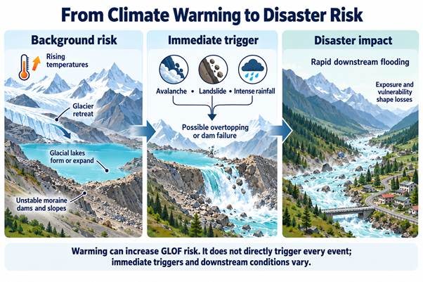
Climate change acts mainly as a risk multiplier.
Higher temperatures accelerate glacier mass loss and can promote the formation and expansion of glacial lakes. Melting ice can also destabilise surrounding slopes and exposed terrain.
However, climate change does not by itself establish the cause of every individual GLOF. A specific event may require an immediate trigger such as an avalanche, landslide or extreme precipitation.
This distinction is important between long-term hazard amplification and immediate disaster causation.
Monitoring and Early Warning
Risk reduction begins with inventorying, mapping and prioritising dangerous lakes.
Satellite remote sensing is particularly useful because many glacial lakes are located in inaccessible terrain. Synthetic Aperture Radar can assist monitoring even when cloud cover limits ordinary optical imagery.
NRSC's National Hydrology Project also uses glacial-lake databases, risk ranking and hydrodynamic modelling to identify possible downstream flood zones.
At high-risk lakes, ground sensors, automated weather systems and downstream warning systems can increase evacuation lead time.
Structural Risk Reduction
Some dangerous lakes can be made safer by gradually lowering their water level.
Possible measures include controlled drainage, pumping, siphoning, engineered outlet channels and tunnels through or beneath unstable barriers.
But such interventions require careful geological assessment because poorly designed intervention can itself destabilise the lake.
Core Policy Lesson
GLOFs are not only glaciological events; they are compound mountain disasters involving climate, geology, hydrology and human exposure.
India's Himalayan strategy therefore needs continuous satellite monitoring, field assessment of high-risk lakes, transboundary hydrological cooperation, stronger early-warning systems and climate-resilient planning of roads, settlements and hydropower projects.
The objective is not to eliminate Himalayan hazards, but to prevent a sudden natural event from becoming a large human disaster.
Probable Mains Question
“Climate change is increasing the background conditions for Glacial Lake Outburst Floods, but disaster severity ultimately depends on physical triggers and downstream exposure.” Explain and discuss measures required to reduce GLOF risk in the Himalayan region.
Prelims Drill
MCQ 1
With reference to Glacial Lake Outburst Floods, consider the following statements:
- Moraine dams are generally composed of unconsolidated material deposited by glaciers.
- A landslide or avalanche entering a glacial lake can contribute to sudden overtopping and dam failure.
- Every expanding glacial lake necessarily produces a GLOF.
Which of the statements given above are correct?
A. 1 only
B. 1 and 2 only
C. 2 and 3 only
D. 1, 2 and 3
Correct Answer: B
Explanation: Moraine dams can be structurally weak, and avalanches or landslides may trigger overtopping or failure. However, an expanding glacial lake does not necessarily produce a GLOF.
MCQ 2
Consider the following statements regarding GLOF risk reduction:
- Synthetic Aperture Radar can assist monitoring of glacial lakes even under cloudy conditions.
- Lowering the volume of water stored in a dangerous lake can reduce potential flood magnitude.
- Satellite monitoring eliminates the need for ground-based early-warning systems.
Which of the statements given above are correct?
A. 1 only
B. 1 and 2 only
C. 2 and 3 only
D. 1, 2 and 3
Correct Answer: B
Explanation: Remote sensing is valuable for identifying and monitoring glacial lakes, while structural measures can reduce stored water. However, satellite monitoring complements rather than replaces field monitoring and downstream early-warning systems.
More Current Affairs - Daily
- Nashik–Trimbakeshwar Simhastha Kumbh Mela (2026–28): Faith, Heritage and Public Governance 31 Oct 2026
- Punjab’s Drug Crisis: Challenges of Public Health, Law Enforcement and Rehabilitation 31 Oct 2026
- Children’s Right to Internet Access 31 Oct 2026
- Siang Upper Multipurpose Project: Questions of Development, Displacement and Environmental Ethics 31 Oct 2026